2/12/25 Prices
International wheat values, cash and futures, saw little change overnight. Spring wheat out of the US Pacific Northwest was a little firmer. The day to day conversion comparison for DNS spring wheat was up roughly AUD$3.90 per tonne, while other grades were generally flat to a touch softer. Cash markets for the other grades generally tracking closer to their underlying futures contracts. Canadian spring wheat out of the PNW also a smidge lower.
The trade found support for weaker US wheat values from the USDA weekly export inspections data. For the week ending Nov 27th wheat failed to impress, with just 385kt of US wheat being loaded for export. This was below the lowest trade estimate leading up to the release of the data, and 95kt below last weeks total loadings. US year to date wheat loadings stand at 13.228mt, up 20% year on year.
US corn export loadings were solid at 1.421mt, higher than the highest trade estimate prior to the release of the report, and taking year to date export inspections to 18.968mt, 71% ahead of this time last year. So what did corn futures do with this impressive data. Well they fell obviously.
The strong export data for corn is keeping US sorghum values moving in the right direction. Both Corpus Christi and Texas FOB values were a little higher as were C&F China values. Offers out of Argentina were also on the increase, the day to day conversion comparison back to an equivalent ex farm LPP price using China as the consumption point saw Argie sorghum increase by about AUD$5.00 / t. US FOB values were up roughly AUD$1.50/t when compared to yesterdays conversions.
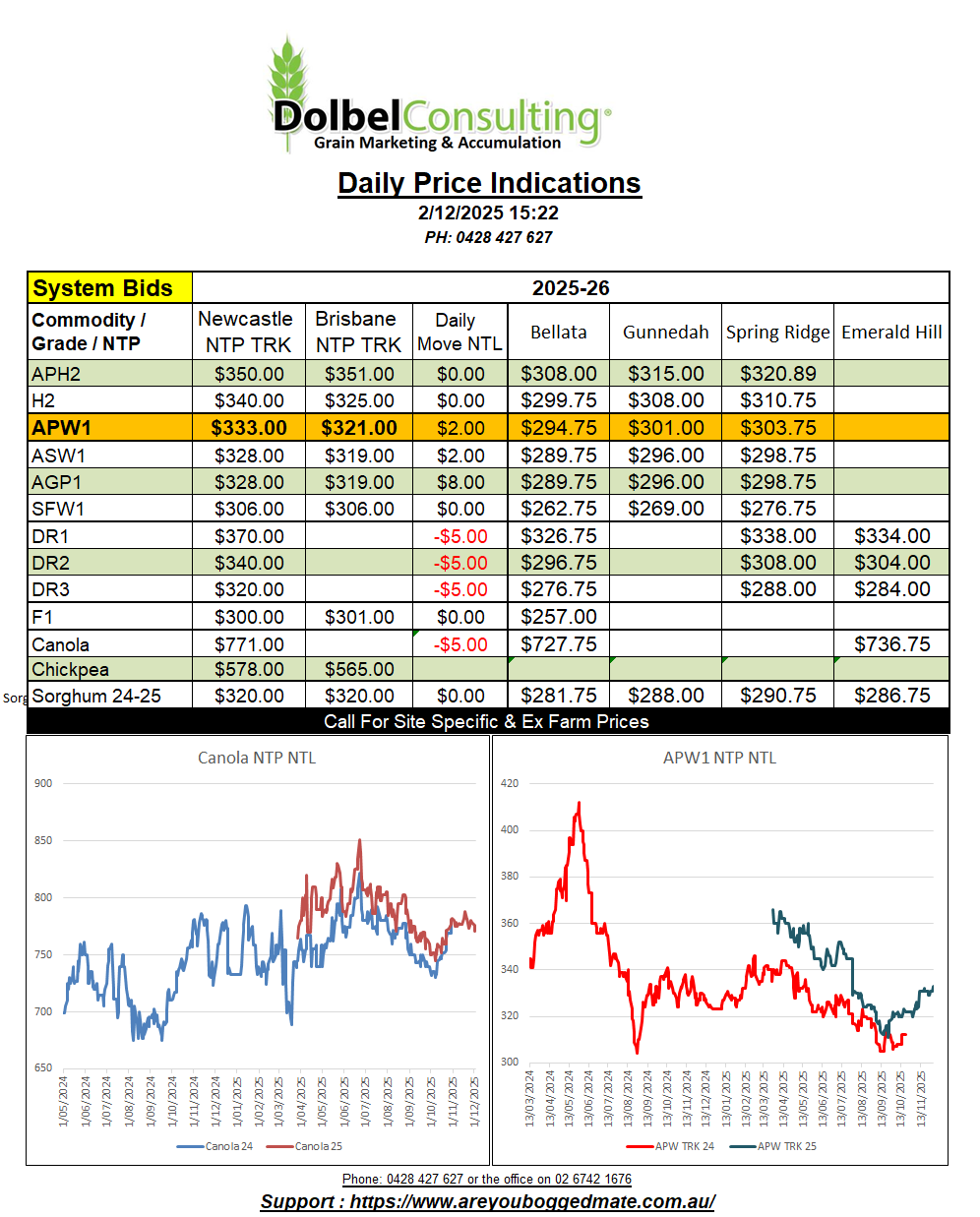
Paris rapeseed futures shed €4.25 in the Feb slot overnight, possibly weighing on local values here today.
A few more producers are winding up their winter crop program on the Liverpool Plains this week. Quality remains variable, screenings creating a few issues in crops that tried to fill 4-5 wide seems to be the biggest problem. The dry finish pinching these grain off. Test weight remains good though, so most wheat is making AUH2, AGP1 or SFW1. The SFW1 market remains range bound, product being booked for December pickup at $300 XF SE LPP yesterday.
The trade continue to look for ASW into the Tamworth market but the grades seem to be mostly SFW1 or H2 or better, there’s not a lot of low screening, low protein wheat on the plains this year. I’ve said it before and I’ll say it again, ASW is actually a difficult grade to grow on purpose.
H2 grade was booked into the port at $360 and was also bid at $312 ex farm C-LPP for Dec / Jan pickup.
DR1 was bid at $380 delivered Newcastle port for Jan / Feb / March, so probably March delivery. This worked back to roughly $335 ex farm C-LPP. Local homes were bid at $372 delivered for a similar delivery window, equating to a value closer to $350 ex farm equivalent, and an easier logistical option than the port. International durum numbers still show a value of something close to US$345 C&F Italy should be achievable. On the back of an envelope that number would equate to a Port Newcastle value of something close to AUD$409. Offers of $400 delivered port Newcastle were rejected yesterday.
Chickpeas delivered to the local packer were generally softer, though there were a couple of reports of traders paying up for specific parcels. The best number was into Brisbane at $620 delivered prompt, or into Narrabri / Wee Waa at $540 delivered prompt. Still no confirmation on Indian sown area for 2026.
A large area of high pressure moving across central Australia will dominate our weather this week. This morning’s cool start as the southerly air flow moves across NNSW should give way to a mild day, pushing towards 27C. Tomorrow morning is expected to be cool again but as the high cell moves further east we should start to see both the morning and daytime temperatures start to increase and return to more normal values by Thursday.
As the high begins to move off shore and airflow here becomes more NE-NW temperatures will become hot, possibly reaching 39C on Saturday afternoon.
A change is due through on Sunday, possibly producing a shower or two and also reducing the temperature back to the low 30s.
The ECMWF model predicts a trough to develop across NSW on Saturday afternoon. Airflow from the cooler SW will mix with hot air moving in from the NW along a trough stretching from Sydney to White Cliffs on Saturday afternoon.
Storms will initially become active around Orange on Saturday afternoon. The trough should move across the LPP very late Saturday or early Sunday morning, showers increasing from the south and rolling off the Liverpool Ranges onto the plains early Sunday. Showers are likely to persist across the LPP through Sunday morning, possibly developing into storms towards the east as some heat comes into the day.